A siren goes off in the distance. It’s not stopping and the anxiety I feel rises with every second it continues. That sound, a warning, signals conditions are “right” for a tornado. Even though that siren just started, the ingredients that brought us to this moment were mixed much earlier.
Building a Supercell
Everything begins in the upper parts of the troposphere, which roughly spans the lowest 6 miles (10 km) of our atmosphere and contains all of the earth’s weather. Thermal winds, as the name implies, were caused by differences in temperature. However, contrary to the name a thermal wind is not really a wind. There’s an old saying, “You can’t fly a kite in thermal wind.” Technically, it’s the difference in wind between two levels of the atmosphere. Colder air is denser than warmer air. This creates differences in thickness values, the vertical distance between two pressure levels. Think of a sandwich under a brick. The differences in the thickness values from cold to warm create a pressure gradient generating the speedier winds
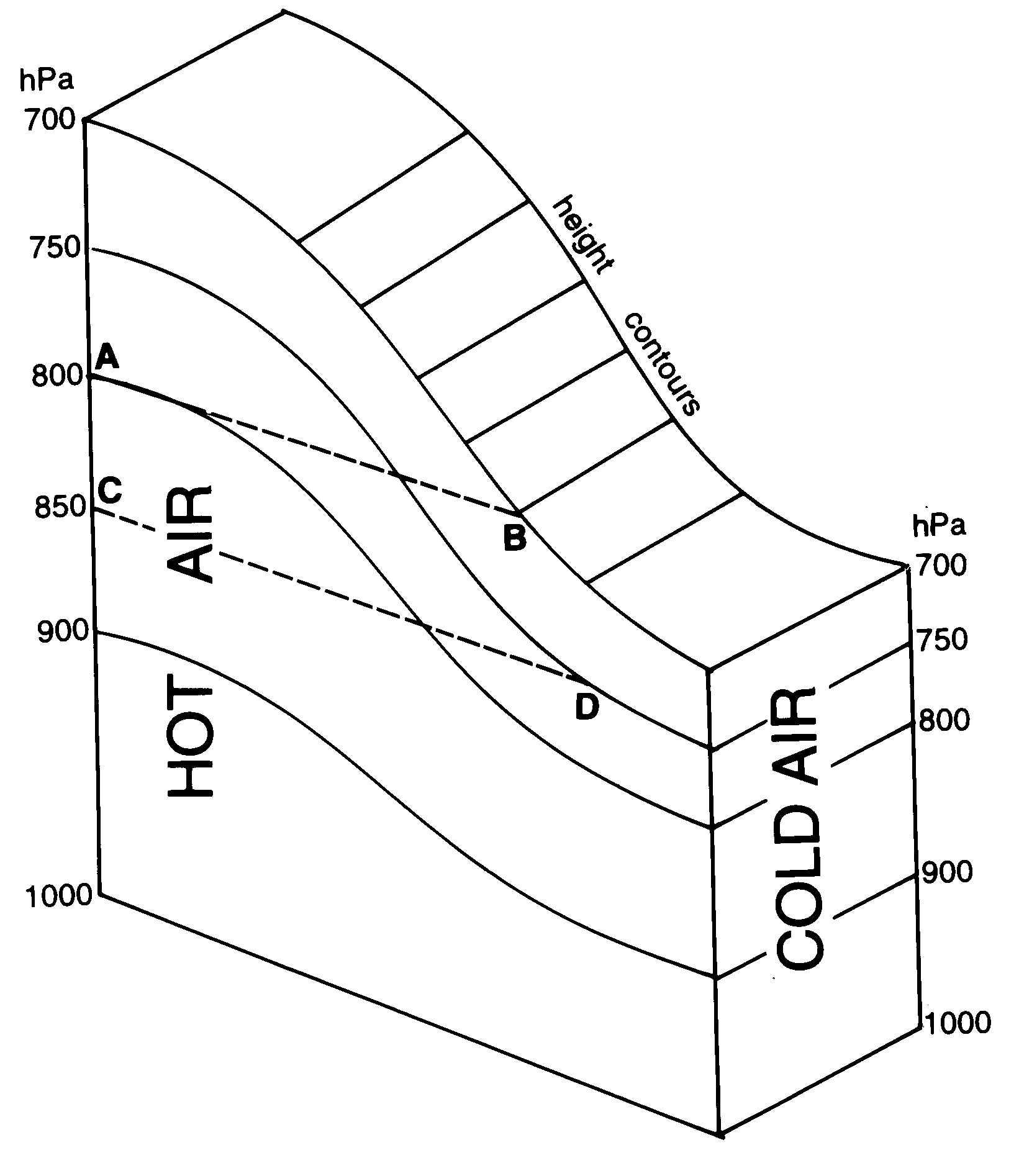
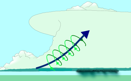
Winds in the upper troposphere are now moving faster than wind closer to the ground. This creates vertical wind shear, more simply put is a change in wind speed or wind direction with height. Much like a paddle wheel, this wind shear generates horizontal rotation. This is the rotation of the tornado in its very infancy but much more is needed for birth.
The second ingredient-rotating updraft
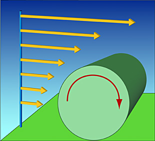
For the next step, this horizontal rotation needs to become vertical. In the middle troposphere, westerly winds are transporting a cool, dry air mass over the warm moist air coming from Gulf of Mexico. The overlap of these two air masses creates instability. The hot air wants to rise because it’s less dense. The energy of the rising air can be measured as convective available potential energy (CAPE), the total amount of energy a parcel of air would have if lifted a certain distance vertically through the atmosphere. Higher CAPE values indicate more energy. This updraft can tilt the horizontal rotation into vertical rotation.
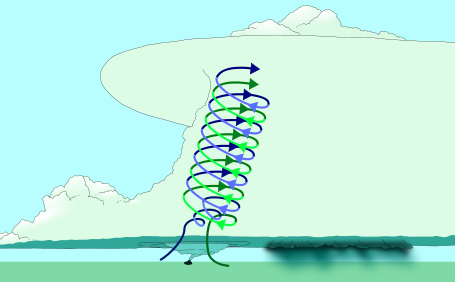
However, a cap of warmer air prevents this. This layer of air originated in the desert southwest. Some of this Southwestern air gets lofted. The warm dry air eventually rides over the warm moist air from the Gulf of Mexico. Now warm, moist air from the Gulf is beneath the warm, dry air from the desert Southwest. The cap is stable and prevents the updrafts from penetrating very high into the atmosphere, but as the day progresses, the conditions change. By mid to late afternoon, during peak heating, the rising air from the surface layer of air is warmer than the cap. The cap is broken and air can now ascend several miles into the sky. A thunderstorm with a rotating updraft, a supercell, has now developed.
 Turning a Supercell into a Torndao
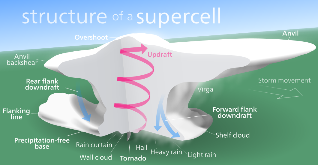
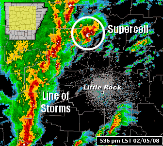
Not all supercells produce tornadoes. Indeed, 70% of the time a tornado warning is issued no tornado actually forms. The when, where, and how of which storm will make tornado is one of the biggest questions in tornado science. Scientists hypothesize the key to tornadogenesis is a downdraft occurring on the backside of the storm, the rear-flank downdraft (RFD). This downdraft forms as some of the falling precipitation wraps around the updraft producing a characteristic hook echo on radar. The RFD brings rotation from aloft to the ground. The RFD can even generate additional horizontal rotation that can be titled into the vertical rotation. This results in a region of broad rotation at the surface, but a tornado is defined as a “violently rotating column of air in the contact with the ground.” As the air from the RFD converges beneath the updraft, it can be ingested by the updraft, amplifying its rotation exponentially. Think of the age-old physics example of a figure skater bringing his or her arms closer to increase the speed of his or her spin. The air is more likely to enter the updraft if it is relatively warm, since warmer air is less dense than cold air. With the third and final ingredient the warning has become reality.
Special thanks to Gabe Garfield (@WxGabe), research meteorologist for the National Weather Service, and Jeff Frame (@VORTEXJeff), Assistant Professor of Atmospheric Sciences at University of Illinois, for both teaching me about tornadoes but providing feedback on this post.
Featured image above from Daniel Rodriguez on Flickr. taken from just north of Banner Rd and 15th Street.