
On a Friday in July of 1986, tornadoes touched down in the suburbs of the Twin Cities in Minnesota. A KARE News11 helicopter caught one of these tornadoes on video, a rarity in the era before YouTube videos and hundreds of storm chasers. This video proved to be exceptional, capturing a vortex structure only previously seen in a laboratory setting years earlier by Purdue scientists. When the scientists tweaked the winds entering the bottom and leaving the top of the small laboratory tornado, the twister took on a helical structure. The KARE video was the best documentation to date of an actual tornado with a helical structure, a video that a seven-year-old Robin Tanamachi watched repeatedly. Robin’s father had recorded the KARE broadcast—a videotape Tanamachi quickly wore out from multiple viewings. From an early age, it was quite clear Tanamachi was destined for a career in tornado science.
Almost thirty years later, Tanamachi, now a Research Scientist for the Cooperative Institute for Mesoscale Meteorological Studies in Norman, Oklahoma, examines how radar can be better used to understand, predict, and track tornadoes. Prior to radar, most research on tornadoes was based on films, still photographs, or damage markings (think of the Fujita scale). Although radar originated in the 1950’s, visible radar evidence of a tornado, the tornado vortex signature, was not discovered until 1973 based on observation of a tornado in Union City, Oklahoma. Interestingly, this was the same year that Gold Earring had the hit Radar Love. That discovery by scientists at the National Severe Storms Laboratory in Oklahoma led to the modern tornado warning system in the U.S, including a national network of next-generation Doppler radars (NEXRAD, also known as WSR-88D) funded by Congress.
Radars are a paradox of simplicity and complexity. Scientists, like Tanamachi, continue to develop and refine radar technology, the kinds of data radar can produce, and the algorithms used to sort through all this data. At its simplest, radar emits a burst of radio waves moving near the speed of light until they come in contact with a target. The target absorbs and re-radiates the waves back, an echo, to the radar antenna. The larger and/or harder the target (e.g., raindrops or hail), the louder the echo. The time that passes for the wave to leave and echo back is a function of the distance traveled by the wave. Each NEXRAD radar pulse lasts about 0.00000157 seconds (1.57×10⁻⁶), with a 0.00099843-second (998.43×10⁻⁶) “listening period” for echos. The radar is “on” for a just over 7 seconds each hour. The remaining 59 minutes and 53 seconds are spent listening for any returned signals.
 The strength and retrieval time of the echo are just two facets of the radar wave measured. Doppler radar also measures the frequency of the echo waves. A shift in the frequency of the wave can yield an estimate of how fast the target is moving away or toward the radar antenna. A positive frequency shift implies motion toward the radar and a negative shift suggests motion away from the radar. This is similar to the Doppler shift you hear with sound waves as a loud pick up truck moves toward or away from you.
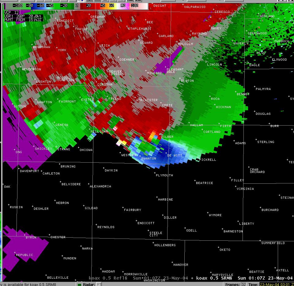
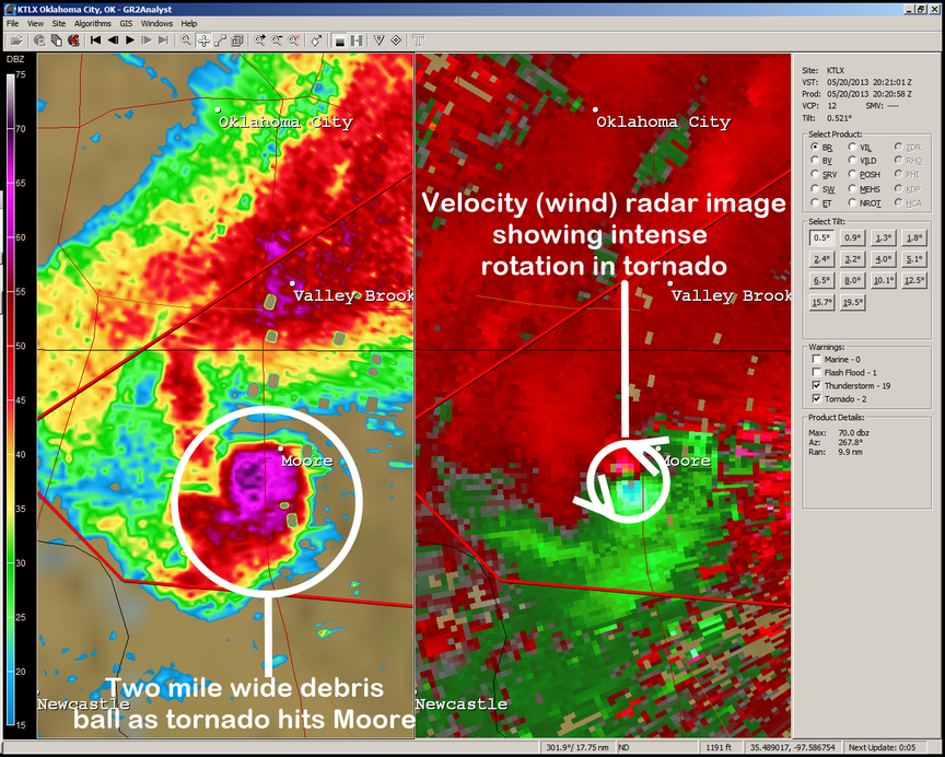
Because of the earth’s curvature, NEXRAD radar beams typically overshoot the tornado itself, and instead measure the winds in the parent mesocyclone that births the tornado.” The tornado vortex signature appears on the radar as red (indicating high outbound velocity) and green (inbound velocity) pixels occurring adjacent to each other over a relatively small area (see radar image above). This is also called a velocity couplet, and it is associated with the mesocyclone, the rotating vortex of air within in the supercell. Radar can also be used to detect a hook echo extending from the rear part of the storm, resulting from precipitation wrapping around the backside of the rotating updraft. Lastly and perhaps disconcertingly, radar can detect the debris ball from a tornado. Objects lofted into the air by a tornado reflect radar waves very well.
 The future of tornado research in part, however, rests on getting the radar closer to the tornado. Moving the radar closer to the storm allows the parts of tornado and storm structure to be better observed. Tanamachi is part of team that drives mobile Doppler radars toward, not away from tornadoes, striving to accomplish this daunting task. This is high-risk-but-high-reward science. Out of 100’s of trips, Tanamachi’s team has only successfully collected data a handful of times. “In the unsuccessful cases an ingredient was missing. We will go out if three of the four are present, but even when all four are present something will still be off and a tornado will not form.” But those few successful cases hold one key to the million-dollar question, understanding when tornadoes will form.
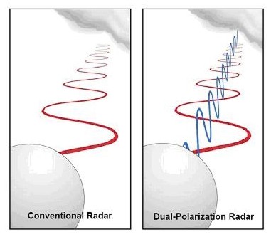
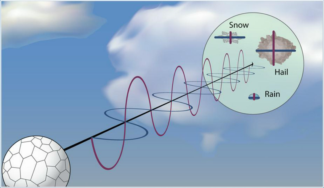
If one key is getting closer to tornadoes with radar, then another is dual-polarized (“dual-pol” for short) radar. Dual-pol radar can emit both horizontal and vertical pulses, allowing for the shapes and sizes of objects to be detected. Contrary to the tear-shaped raindrops of cartoons, raindrops in real life can take on a variety of shapes. Small raindrops are almost perfectly spherical, returning the same amount of echo in the horizontal and vertical polarized channels. Larger drops, deformed by air drag, resemble hamburger buns returning a stronger horizontal echo. Tanamachi notes, “These subtle differences in the drop shape can lead to vastly different estimates of how much liquid water actually falls on the ground. Dual-polarized radar has been conclusively shown to make radar-based rainfall estimates more accurate.”
 The size a raindrop can also inform meteorologists about cooling and temperatures— possible triggers for tornadoes. Water molecules on smaller drops with their spherical shape and high surface area-to-volume ratio can evaporate more quickly than large drops. This increased evaporation with smaller drops causes the air to chill and sink toward the ground and important in birth of tornado. As Tanamachi explains “Once the cool downdraft reaches the ground, it spreads outward like a puddle of syrup, in what is termed the storm’s “cold pool”. Such downdrafts appears to be a two-edged sword in relation to tornadogenesis. On one hand, several studies suggest that a downdraft is necessary to generate near-surface rotation. On the other hand, the fuel source for the storm (and tornado) is warm, moist, buoyant air, which may be disrupted or cut off if the resulting cold pool completely undercuts the storm, as many a frustrated storm chaser can tell you. It seems there is a “Goldilocks problem” at hand – the downdraft must be present, but not too strong – in order to enhance tornado formation.” Dual-pol can indicate these inner storm dynamics all by detecting small or large raindrops that in turn suggest the presence and strength of downdrafts leading to predictions on potential of that storm to produce a tornado.